

CARTO
by CARTO
What is CARTO?
Get Best Quote for CARTO
Connect with SaaSrat experts to get the best quote for your business.
You're all set!
A specialist for CARTO will reach out within 1 business day.
CARTO Features
Spatial data visualization
Geospatial analytics
Location intelligence
Customizable dashboards
Data enrichment
Real time data processing
View All 37 Features
CARTO Resources
CARTO Screenshots
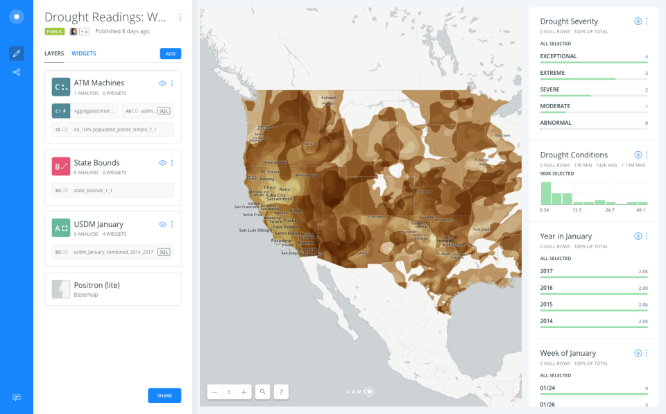
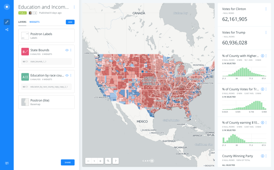
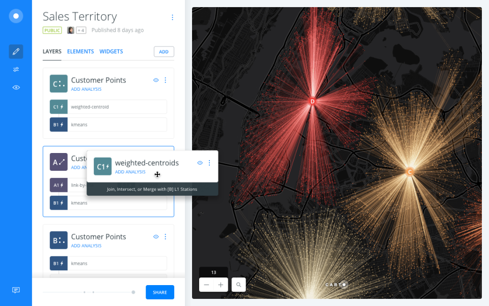
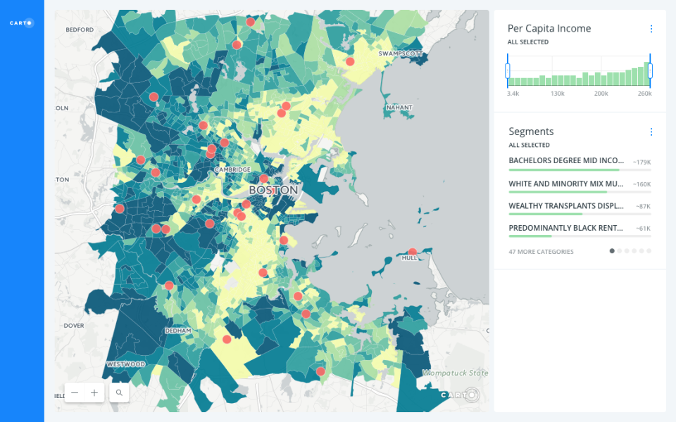
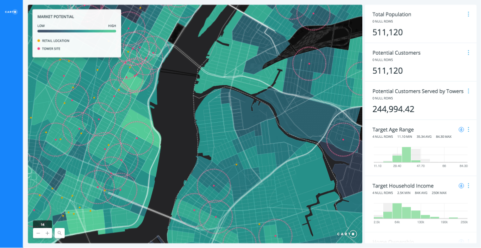
Description
CARTO at a Glance
| Best for | Data analysts using low-code spatial workflows, data scientists leveraging ML/AI on geospatial data, GIS professionals transitioning from desktop GIS tools, and developers building location-intelligent applications on top of enterprise data warehouses (BigQuery, Snowflake, AWS Redshift) |
|---|---|
| Deployment | Cloud-native platform running on BigQuery, Snowflake, and AWS Redshift; AI Agents; deck.gl and GPU-accelerated visualization; framework-agnostic app development |
| Starting price | Contact Vendor (request demos or try the platform free through the vendor website; enterprise pricing scoped by data volume and user count) |
| Key strengths | Agentic GIS Platform positioning, cloud-native warehouse-first architecture, 100+ pre-built analysis components, AI Agents for custom organizational needs, natural language interaction, billions-of-points visualization, deck.gl GPU technology, Verizon/Vodafone/Ford/JLL/Unilever/AXA/Booking/BT Group/Coca-Cola named customers |
| Not ideal for | Organizations without a modern data warehouse (BigQuery, Snowflake, AWS Redshift), or teams needing desktop GIS with specialized cartographic capabilities beyond cloud-native analytics |
CARTO Overview
CARTO is the Agentic GIS Platform, a cloud-native geospatial analytics solution that operates directly within enterprise data warehouses. Rather than requiring separate spatial data infrastructure, CARTO runs on top of BigQuery, Snowflake, and AWS Redshift.
The warehouse-native architecture is genuinely decisive. Traditional GIS creates spatial data silos separate from enterprise data warehouses; CARTO eliminates that silo by keeping spatial analysis in the same data warehouse where enterprise data already lives.
Four target user personas reflect the specific geospatial analytics reality: data analysts using low-code workflows, data scientists leveraging ML/AI integration, GIS professionals transitioning from traditional desktop GIS tools, and developers building location-intelligent applications.
The Analytics module provides drag-and-drop interface with 100+ pre-built analysis components and native ML/AI integration. Rather than requiring coding for spatial analysis, low-code workflows enable analysts to build spatial workflows visually.
The Visualization module handles billions of data points with natural language interaction and AI Agent-powered insights. Modern geospatial datasets scale to billions of points; visualization must handle that scale.
AI Agents delivering custom agents built to organizational needs address the specific enterprise reality where different organizations have distinct geospatial decision patterns. Rather than one-size-fits-all AI, custom agents match specific use cases.
The App Development framework using deck.gl and GPU technology is framework-agnostic. Developers building location-intelligent applications benefit from deck.gl (from Uber) plus GPU acceleration.
Named enterprise customers span telecom (Verizon, Vodafone, BT Group), automotive (Ford), real estate (JLL), consumer goods (Unilever, Coca-Cola), insurance (AXA), and travel (Booking). Cross-vertical enterprise geospatial adoption at Fortune 500 scale.
Capabilities and Named Features
The CARTO thesis is that geospatial analytics must run inside the enterprise data warehouse where data already lives, and Agentic GIS Platform with AI Agents plus warehouse-native architecture delivers real spatial analysis value against desktop GIS with data silos.
The cloud-native warehouse-first architecture is genuinely decisive. Traditional GIS creates spatial data silos separate from enterprise data warehouses; CARTO eliminates that silo entirely by running spatial analysis directly on BigQuery, Snowflake, and AWS Redshift.
AI Agents as customizable agents built to organizational needs address the specific enterprise reality where different organizations have distinct geospatial decision patterns. Rather than one-size-fits-all AI, custom agents match specific use cases across verticals.
The Analytics module with drag-and-drop interface plus 100+ pre-built analysis components plus native ML/AI integration addresses the specific reality that data analysts need low-code workflows for spatial analysis rather than requiring GIS coding expertise.
The Visualization module handling billions of data points with natural language interaction addresses the modern geospatial scale where enterprise data reaches billion-point volumes; traditional GIS visualization cannot handle this scale.
The App Development framework using deck.gl (from Uber) and GPU technology addresses the specific developer reality where location-intelligent applications require high-performance rendering. deck.gl plus GPU acceleration deliver that performance natively.
Cross-persona coverage (data analysts, data scientists, GIS professionals, developers) matters strategically. Different roles have different geospatial needs; CARTO serves all four rather than being specialist-only.
Named enterprise customer breadth across telecom (Verizon, Vodafone, BT Group), automotive (Ford), real estate (JLL), consumer goods (Unilever, Coca-Cola), insurance (AXA), and travel (Booking) demonstrates cross-vertical enterprise geospatial adoption at Fortune 500 scale.
Named feature list
- Agentic GIS Platform
- Cloud-native geospatial analytics
- BigQuery integration
- Snowflake integration
- AWS Redshift integration
- Drag-and-drop interface
- 100+ pre-built analysis components
- Native ML/AI integration
- AI Agents
- Custom organizational agents
- Natural language interaction
- Billions of data points visualization
- deck.gl technology
- GPU-accelerated rendering
- Framework-agnostic development
- Data analyst workflows
- Data scientist workflows
- GIS professional workflows
- Developer SDK
- End-to-end decision support
Pricing and Plans
CARTO does not publish public pricing on the homepage.
Enterprise pricing is scoped based on data volume (queries executed against BigQuery, Snowflake, or AWS Redshift), user count across the four personas (data analysts, data scientists, GIS professionals, developers), and AI Agent configuration.
Prospective buyers request demos or try the platform free through the vendor website; enterprise geospatial procurement typically includes operational assessment before pricing conversations.
The warehouse-native architecture means CARTO cost is separate from warehouse compute cost; organizations already pay for BigQuery, Snowflake, or AWS Redshift queries and CARTO adds the spatial analytics layer.
| Tier | Price | What is included |
|---|---|---|
| Analytics | Contact Vendor | Drag-and-drop analytics with 100+ pre-built spatial analysis components and native ML/AI integration |
| Visualization | Contact Vendor | Billions-of-points visualization with natural language interaction and AI Agent-powered insights |
| AI Agents | Contact Vendor | Custom AI agents built to organizational needs for end-to-end decision support |
| App Development | Contact Vendor | Framework-agnostic development using deck.gl and GPU technology for location-intelligent applications |
| Enterprise | Contact Vendor | Enterprise deployment with expanded data volume, multi-warehouse configuration, and dedicated support |
Pros
- Cloud-native warehouse-first architecture eliminates traditional GIS data silos by running spatial analysis directly on BigQuery, Snowflake, and AWS Redshift where enterprise data already lives.
- AI Agents as customizable agents plus natural language interaction plus 100+ pre-built analysis components deliver low-code and AI-first spatial analytics that desktop GIS cannot match.
- Named enterprise customers (Verizon, Vodafone, Ford, JLL, Unilever, AXA, Booking, BT Group, Coca-Cola) demonstrate cross-vertical Fortune 500 adoption providing procurement credibility.
Cons and Trade-offs
- Organizations without a modern data warehouse (BigQuery, Snowflake, AWS Redshift) cannot use CARTO; the platform is warehouse-first architecture.
- Teams needing desktop GIS with specialized cartographic capabilities beyond cloud-native analytics may prefer ArcGIS or QGIS.
- Quote-based enterprise pricing slows self-serve evaluation versus published-price competitors.
CARTO vs Alternatives
| Capability | CARTO | ArcGIS (Esri) | QGIS |
|---|---|---|---|
| Core focus | Agentic GIS on data warehouses | Enterprise desktop plus cloud GIS | Open-source desktop GIS |
| Warehouse-native architecture | Native BigQuery/Snowflake/Redshift | ArcGIS integrations | Not primary focus |
| AI Agents | Native custom agents | Esri AI features | Not primary focus |
| deck.gl visualization | Native GPU-accelerated | ArcGIS visualization | QGIS visualization |
| Best fit | Enterprises on modern data warehouses wanting Agentic GIS | Enterprises wanting Esri ecosystem | Open-source desktop GIS users |
Who Should Choose CARTO
Data analysts using low-code spatial workflows, data scientists leveraging ML/AI on geospatial data, GIS professionals transitioning from desktop GIS tools, and developers building location-intelligent applications on top of enterprise data warehouses (BigQuery, Snowflake, AWS Redshift).
Enterprises already on modern data warehouses benefit directly from the warehouse-first architecture; CARTO operates on top of existing BigQuery, Snowflake, or AWS Redshift investment.
Not appropriate for organizations without a modern data warehouse or teams needing desktop GIS with specialized cartographic capabilities beyond cloud-native analytics.
Named Alternatives to CARTO
- ArcGIS (Esri). Enterprise desktop and cloud GIS category incumbent. Chosen for enterprises wanting Esri ecosystem breadth.
- QGIS. Open-source desktop GIS. A better fit for teams wanting free open-source desktop GIS.
- Mapbox. Location platform for developers. Preferred for consumer-facing map applications.
- Google Maps Platform. Google location APIs. Chosen for teams wanting Google location services.
- Kepler.gl. Open-source geospatial visualization from Uber. A better fit for teams wanting Kepler.gl open-source foundation.
Implementation and Deployment
CARTO deployments typically run 4-16 weeks for enterprise organizations depending on data warehouse configuration, geospatial dataset scope, user persona mix, and AI Agent customization.
Standard sequence: modern data warehouse assessment (BigQuery, Snowflake, AWS Redshift), CARTO platform configuration for the specific warehouse, initial spatial dataset onboarding, Analytics module setup with 100+ pre-built analysis components, Visualization module configuration for the specific data scale, AI Agent customization built to organizational geospatial decision patterns, App Development framework setup with deck.gl if developers building applications, user persona training (data analysts, data scientists, GIS professionals, developers), and phased rollout across enterprise geospatial teams.
Multi-warehouse enterprise deployments phase in additional warehouse connections sequentially with shared spatial dataset governance.
Enterprise deployments layer on additional AI Agent customization and dedicated support for organization-specific geospatial workflows.
What Real Buyers Say About CARTO
Operator discussions on LinkedIn Geospatial Community and Reddit r/gis modern data warehouse threads surface the following themes.
GIS directors and geospatial analytics leaders on LinkedIn geospatial community discussions cite CARTO as decisive when they need Agentic GIS Platform that runs directly on modern data warehouses rather than requiring separate spatial data infrastructure.
The named enterprise customers (Verizon, Vodafone, Ford, JLL, Unilever, AXA, Booking, BT Group, Coca-Cola) are frequently cited during Fortune 500 procurement conversations; enterprise geospatial buyers trust references from actual peer Fortune 500 organizations across telecom, automotive, real estate, consumer goods, insurance, and travel verticals.
Operator discussions in geospatial analytics communities highlight the warehouse-native architecture as decisive against traditional GIS with data silos; CARTO eliminates the silo entirely by running spatial analysis inside BigQuery, Snowflake, or AWS Redshift.
Common critique from desktop GIS buyers: CARTO is cloud-native focused; teams needing specialized cartographic capabilities beyond cloud-native analytics may prefer ArcGIS or QGIS.
AI Agents plus natural language interaction plus 100+ pre-built analysis components are repeatedly praised as decisive against desktop GIS requiring specialized expertise; low-code plus AI-first analytics democratize spatial analysis across data analyst, data scientist, and business user personas.
The deck.gl plus GPU technology is frequently discussed by developers as decisive for location-intelligent applications requiring high-performance rendering at billions-of-points scale.
Vendor references: CARTO Agentic GIS Platform overview, CARTO Fortune 500 customers, CARTO platform capabilities.
Related CARTO Comparisons and Categories on SaaSRat
Explore related products and categories on SaaSRat to compare CARTO against alternatives.
The Bottom Line on CARTO
CARTO is a strong fit for data analysts using low-code spatial workflows, data scientists leveraging ML/AI on geospatial data, GIS professionals transitioning from desktop GIS tools, and developers building location-intelligent applications on top of enterprise data warehouses.
Warehouse-native architecture plus AI Agents plus natural language interaction plus 100+ pre-built analysis components plus deck.gl GPU visualization deliver Agentic GIS depth desktop GIS cannot match.
Named Fortune 500 customers (Verizon, Vodafone, Ford, JLL, Unilever, AXA, Booking, BT Group, Coca-Cola) provide cross-vertical enterprise geospatial procurement credibility.
Organizations without a modern data warehouse should evaluate desktop GIS alternatives like ArcGIS or QGIS.
Teams needing specialized cartographic capabilities beyond cloud-native analytics should evaluate ArcGIS Pro.
Verified on 2026-08-04 against vendor website.
Frequently Asked Questions
What is CARTO?
Who is CARTO best for?
How does CARTO pricing work?
What data warehouses does CARTO support?
What are CARTO AI Agents?
Which named customers does CARTO have?
What is deck.gl?
How does CARTO compare to ArcGIS?
Where is CARTO headquartered?
What can I visualize with CARTO?
Find Your Perfect Software
See how it can transform your workflow
- Personalized for your needs Tailored recommendations based on your unique requirements.
- Save time & resources Streamline your workflow and boost team productivity.
- Trusted by thousands Join 10,000+ businesses already growing with SaaSrat.
You're all set! 🎉
A specialist for will reach out within 1 business day with tailored recommendations for your needs.